Rapid urbanization and new construction estimated to be 250 times NYC by 2050, is increasing traffic congestion, pollution, and related health threats. Understanding the consequences of urban design choices on mobility, sustainability, and public health is hence a necessity and it requires a new set of tools that allows urban designers to quantify the impact and performance of mobility solutions, sustainability, public health impacts, pedestrian thermal comfort and pollution exposure during the earliest stages of a design process. Embedded in a generative, performance-driven design process, such a tool can significantly facilitate the design of healthy and sustainable urban habitats that promote active mobility. As part of this CTECH funded project we are developing Ubano [1] – a software tool for architects and urban designers that helps to answer the following high-level questions: Over the course of a year, how does the design enhance active mobility and what kind of health and energy impact will stem from that? Urbano is already used in design practice to do urban network analysis, walkability, and outdoor comfort studies [2,3]. We are quoting Luc Wilson, a senior associate principal at KohnPedersonFox and director of KPF Urban Interface (KPFui):
“Urbano’s mobility simulations in their current form added a new and accessible dimension to the world of integrated urban performance simulation. The proposed new features that link outdoor comfort and environmental parameters to mobility-related behavior are thought after in almost every project. With the continued development of Urbano, I see the great potential that the tool will become a new common language amongst architecture and urban design professionals, consultants, academics and students around the world, uniting communities that until recently operated in silos.”
Figure 1: shows the user interface of Urbano and a walkability study of an NYC neighborhood.

Figure 2: shows preliminary results of a spatial outdoor comfort mapping of Bryant Park.
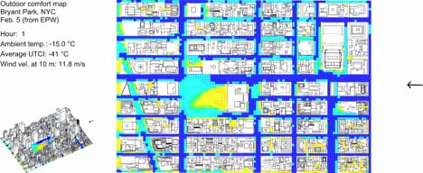
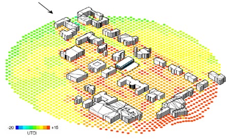
Figure 3: High-Resolution Outdoor Comfort Map of the Cornell Campus.
References:
- Dogan, T., Samaranayake, S., & Saraf, N. (2018). Urbano: A new tool to promote mobility-aware urban design, active transportation modeling and access analysis for amenities and public transport. Presented at the SimAUD, Delft, Netherlands.
- Kastner, P., Dogan, T. (2019). Towards High-Resolution Annual Outdoor Thermal Comfort Mapping In Urban Design. Submitted to Building Simulation 2019, Rome
- Kastner, P., & Dogan, T. (2018). Optimization of meshing methodologies for annual urban CFD simulations. In ESIM Canada 2018. Montreal, Canada: IBPSA Canada.